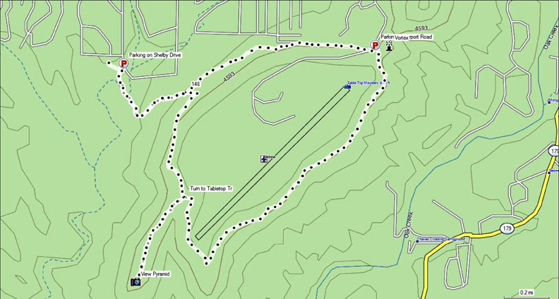
For those of you who have GPS units capable of uploading hike GPS data files, I have GPS data files for more than 90 hikes in the Sedona area, which include hikes to the vortexes and "power spots." The file for the Airport Loop hike is shown below as it appears for my Garmin unit. The files, however, are in the universal gpx format and can be used by any GPS unit no matter what make. All you need to be sure of is that you can upload the data to your portable GPS device from your computer.
If you contact me I'll be glad to send you one hike GPS data file for no charge. You select the hike you'd like to try out and I'll send it to you. Take it for a test run, open the file in Google Earth and take a look at the trail, and make sure you can upload the data to your GPS unit.
Then if you want other Sedona hike GPS data, you have three options:
You can purchase the GPS data for the four main Sedona vortexes plus one "power spot" (Airport, Bell Rock, Boynton Vista, Cathedral Rock and Cowpies) for $5.99
You can purchase the GPS data for the top 10 Sedona hikes (Bear Mountain, Boynton Canyon, Brins Mesa, Devil's Bridge, Doe Mountain, Fay Canyon, Little Horse, Llama, Secret Canyon, West Fork) for $6.99
You can purchase the entire GPS hike data set, including the data for the vortex hikes, top 10 hikes and 65 additional hikes (for a total of more than 90 hikes) for $7.99.
The entire hike data file (some 94 different hikes) includes: Airport Loop, Baldwin Trail, Bear Mountain, Bear Sign, Boynton Canyon, the Boynton vortex, Brins Mesa, Broken Arrow, Chimney Rock, Coffee Pot, Devil's Bridge, etc. etc. etc. Go to the alphabetical list of hikes and look for the ☼ symbol for an idea of hikes included with the total set.
Click the button below and use Paypal to send a payment for the data set you'd like. When you make the payment, I'll email you back a zip file of the GPS data files which you'll download to your computer for uploading to your GPS unit. IF YOU'D LIKE THE ZIP FILE SENT TO AN ADDRESS DIFFERENT THAN THE EMAIL ADDRESS LISTED WITH PAYPAL, PLEASE EMAIL ME
As far as portable GPS units go, I like the Garmin line. I use a model 60 CSx.
Back to the homepage
Great Sedona Hikess
Last Updated May 20, 2019
Web Page by Bill Bohan (billbo@greatsedonahikes.com)